


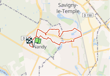
Nandy/SLT

robinier
User

Length
7.6 km

Max alt
90 m

Uphill gradient
38 m
Km-Effort
8.1 km

Min alt
75 m

Downhill gradient
38 m
Boucle
Yes
Creation date :
2023-11-15 08:06:28.0
Updated on :
2023-11-15 10:24:41.252
2h17
Difficulty : Easy

FREE GPS app for hiking
 SityTrail
IGN / Geographical institutes
SityTrail Plus
The world is yours!
About
Trail Walking of 7.6 km to be discovered at Ile-de-France, Seine-et-Marne, Nandy. This trail is proposed by robinier.
Positioning
Country:
France
Region :
Ile-de-France
Department/Province :
Seine-et-Marne
Municipality :
Nandy
Location:
Unknown
Start:(Dec)
Start:(UTM)
467601 ; 5380974 (31U) N.
Comments