


SityTrail - Etape 1 GR5 - E2

collignpn
User GUIDE
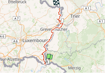

Length
81 km

Max alt
344 m

Uphill gradient
2212 m
Km-Effort
110 km

Min alt
126 m

Downhill gradient
2199 m
Boucle
No
Creation date :
2023-11-15 12:17:07.227
Updated on :
2023-11-15 12:19:44.667
0m
Difficulty : Medium

FREE GPS app for hiking
 SityTrail
IGN / Geographical institutes
SityTrail Plus
The world is yours!
About
Trail Nordic walking of 81 km to be discovered at Unknown, Canton Remich, Schengen. This trail is proposed by collignpn.
Positioning
Country:
Luxembourg
Region :
Unknown
Department/Province :
Canton Remich
Municipality :
Schengen
Location:
Unknown
Start:(Dec)
Start:(UTM)
309229 ; 5483296 (32U) N.
Comments