


Col du Soulor depuis Aucun

chasle
User
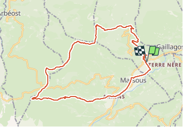

Length
23 km

Max alt
1602 m

Uphill gradient
972 m
Km-Effort
36 km

Min alt
844 m

Downhill gradient
972 m
Boucle
Yes
Creation date :
2023-11-15 06:51:41.202
Updated on :
2023-11-15 13:38:23.913
5h55
Difficulty : Difficult

FREE GPS app for hiking
 SityTrail
IGN / Geographical institutes
SityTrail Plus
The world is yours!
About
Trail Walking of 23 km to be discovered at Occitania, Hautespyrenees, Aucun. This trail is proposed by chasle.
Positioning
Country:
France
Region :
Occitania
Department/Province :
Hautespyrenees
Municipality :
Aucun
Location:
Unknown
Start:(Dec)
Start:(UTM)
728951 ; 4761684 (30T) N.
Comments