


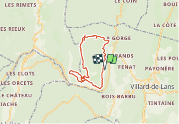
Vercors Le Gros Martel gorge de la Bourne

c.gourme
User


5h44
Difficulty : Medium

FREE GPS app for hiking
 SityTrail
IGN / Geographical institutes
SityTrail Plus
The world is yours!
About
Trail Walking of 14.6 km to be discovered at Auvergne-Rhône-Alpes, Isère, Villard-de-Lans. This trail is proposed by c.gourme.
Description
Au début de la rando suivre les marques bleues. Attention après le dernier point de vue sur les gorges ( on est sur une route goudronnée), descendre et à un petit cairn descendre sur la droite vers la vallée.
Apres le sommet du Gros Martel prendre rapidement une petite sente sur la droite (petit cairn).
La petite sente débouche sur un sentier forestier très boueux; traversé le sentier et descendre tout droit dans la pente : la sente est au départ à peine visible.
Positioning
Comments