


VTT malpasset lac de saint catien 36 km

Gilles Auffret
User
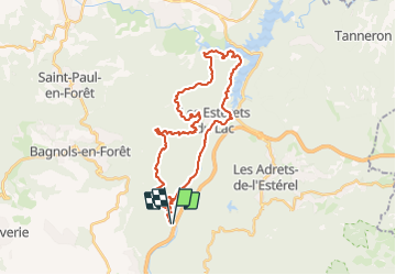

Length
36 km

Max alt
347 m

Uphill gradient
941 m
Km-Effort
48 km

Min alt
38 m

Downhill gradient
940 m
Boucle
Yes
Creation date :
2023-11-15 12:59:01.0
Updated on :
2023-11-15 15:23:14.892
2h23
Difficulty : Very difficult

FREE GPS app for hiking
 SityTrail
IGN / Geographical institutes
SityTrail Plus
The world is yours!
About
Trail Mountain bike of 36 km to be discovered at Provence-Alpes-Côte d'Azur, Var, Fréjus. This trail is proposed by Gilles Auffret.
Positioning
Country:
France
Region :
Provence-Alpes-Côte d'Azur
Department/Province :
Var
Municipality :
Fréjus
Location:
Unknown
Start:(Dec)
Start:(UTM)
318644 ; 4819302 (32T) N.
Comments