


22-10-10 Vins caramy

lygi
User
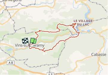

Length
18.3 km

Max alt
390 m

Uphill gradient
531 m
Km-Effort
25 km

Min alt
169 m

Downhill gradient
531 m
Boucle
Yes
Creation date :
2023-11-15 16:35:02.402
Updated on :
2023-11-15 16:35:09.65

FREE GPS app for hiking
 SityTrail
IGN / Geographical institutes
SityTrail Plus
The world is yours!
About
Trail of 18.3 km to be discovered at Provence-Alpes-Côte d'Azur, Var, Vins-sur-Caramy. This trail is proposed by lygi.


Positioning
Country:
France
Region :
Provence-Alpes-Côte d'Azur
Department/Province :
Var
Municipality :
Vins-sur-Caramy
Location:
Unknown
Start:(Dec)
Start:(UTM)
268695 ; 4812757 (32T) N.
Comments