


AG DU 17/11/2023 3.3 KM

CLÉRY Rando
Si tu veux marcher vite, marche seul; si tu veux marcher loin, marche avec les autres.
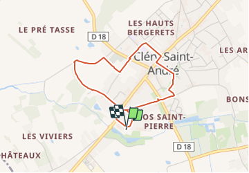

Length
3.3 km

Max alt
99 m

Uphill gradient
20 m
Km-Effort
3.6 km

Min alt
85 m

Downhill gradient
21 m
Boucle
Yes
Creation date :
2023-11-16 10:13:25.938
Updated on :
2023-11-16 10:13:58.862
49m
Difficulty : Easy

FREE GPS app for hiking
 SityTrail
IGN / Geographical institutes
SityTrail Plus
The world is yours!
About
Trail Walking of 3.3 km to be discovered at Centre-Loire Valley, Loiret, Cléry-Saint-André. This trail is proposed by CLÉRY Rando.
Positioning
Country:
France
Region :
Centre-Loire Valley
Department/Province :
Loiret
Municipality :
Cléry-Saint-André
Location:
Unknown
Start:(Dec)
Start:(UTM)
406598 ; 5296569 (31T) N.
Comments