


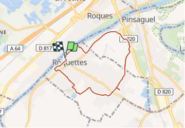
Roquettes facile

pidjam
User

Length
6.9 km

Max alt
166 m

Uphill gradient
45 m
Km-Effort
7.5 km

Min alt
151 m

Downhill gradient
47 m
Boucle
Yes
Creation date :
2023-11-16 13:12:28.77
Updated on :
2023-11-16 14:54:05.978
1h30
Difficulty : Easy

FREE GPS app for hiking
 SityTrail
IGN / Geographical institutes
SityTrail Plus
The world is yours!
About
Trail Walking of 6.9 km to be discovered at Occitania, Haute-Garonne, Roquettes. This trail is proposed by pidjam.
Positioning
Country:
France
Region :
Occitania
Department/Province :
Haute-Garonne
Municipality :
Roquettes
Location:
Unknown
Start:(Dec)
Start:(UTM)
367749 ; 4817696 (31T) N.
Comments