


geyssans birnen

brigitBB26
User
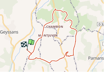

Length
9.5 km

Max alt
364 m

Uphill gradient
188 m
Km-Effort
12.1 km

Min alt
236 m

Downhill gradient
188 m
Boucle
Yes
Creation date :
2023-11-16 12:43:35.552
Updated on :
2023-11-16 15:09:44.642
2h25
Difficulty : Difficult

FREE GPS app for hiking
 SityTrail
IGN / Geographical institutes
SityTrail Plus
The world is yours!
About
Trail Walking of 9.5 km to be discovered at Auvergne-Rhône-Alpes, Drôme, Geyssans. This trail is proposed by brigitBB26.
Positioning
Country:
France
Region :
Auvergne-Rhône-Alpes
Department/Province :
Drôme
Municipality :
Geyssans
Location:
Unknown
Start:(Dec)
Start:(UTM)
665543 ; 4997735 (31T) N.
Comments