


Saint Nazaire

meillon
User
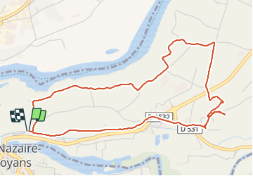

Length
5.9 km

Max alt
246 m

Uphill gradient
81 m
Km-Effort
7 km

Min alt
190 m

Downhill gradient
79 m
Boucle
Yes
Creation date :
2023-11-16 15:02:06.369
Updated on :
2023-11-16 16:46:09.993
1h43
Difficulty : Easy

FREE GPS app for hiking
 SityTrail
IGN / Geographical institutes
SityTrail Plus
The world is yours!
About
Trail Walking of 5.9 km to be discovered at Auvergne-Rhône-Alpes, Isère, Saint-Just-de-Claix. This trail is proposed by meillon.
Description
Entre la Bourne et l Isère...en passant par le château des anges...
Positioning
Country:
France
Region :
Auvergne-Rhône-Alpes
Department/Province :
Isère
Municipality :
Saint-Just-de-Claix
Location:
Unknown
Start:(Dec)
Start:(UTM)
677170 ; 4992352 (31T) N.
Comments