


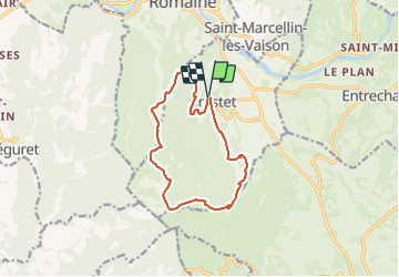
Le Crestet
© OpenStreetMap contributors


3h55
Difficulty : Medium


Length
12.7 km
Max alt
515 m
Uphill gradient
343 m
Km-Effort
17.3 km
Min alt
285 m
Downhill gradient
338 m
Boucle
Yes
Creation date :
2023-11-17 08:40:19.768
Updated on :
2023-11-18 16:39:38.811
3h55
Difficulty : Medium
FREE GPS app for hiking
 SityTrail
IGN / Geographical institutes
SityTrail Plus
The world is yours!
About
Trail Walking of 12.7 km to be discovered at Provence-Alpes-Côte d'Azur, Vaucluse, Crestet. This trail is proposed by les joyeux randonneurs.
Photos


Positioning
Country:
France
Region :
Provence-Alpes-Côte d'Azur
Department/Province :
Vaucluse
Municipality :
Crestet
Location:
Unknown
Start:(Dec)
Start:(UTM)
666453 ; 4898097 (31T) N.
Comments