


montchaboux 2023

goizet
User
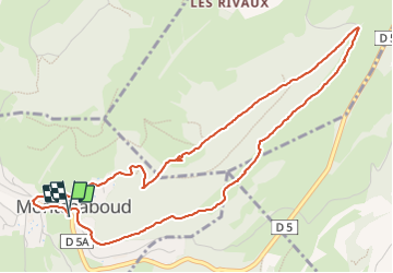

Length
5.8 km

Max alt
738 m

Uphill gradient
257 m
Km-Effort
9.3 km

Min alt
517 m

Downhill gradient
258 m
Boucle
Yes
Creation date :
2023-11-17 12:22:36.162
Updated on :
2023-11-17 15:21:18.605
2h58
Difficulty : Easy

FREE GPS app for hiking
 SityTrail
IGN / Geographical institutes
SityTrail Plus
The world is yours!
About
Trail Walking of 5.8 km to be discovered at Auvergne-Rhône-Alpes, Isère, Montchaboud. This trail is proposed by goizet.
Positioning
Country:
France
Region :
Auvergne-Rhône-Alpes
Department/Province :
Isère
Municipality :
Montchaboud
Location:
Unknown
Start:(Dec)
Start:(UTM)
717556 ; 4997196 (31T) N.
Comments