


Balade Vélo Roland

pconte
User
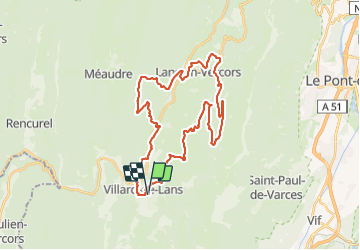

Length
38 km

Max alt
1460 m

Uphill gradient
1055 m
Km-Effort
52 km

Min alt
962 m

Downhill gradient
1060 m
Boucle
Yes
Creation date :
2023-11-17 12:39:55.0
Updated on :
2023-11-17 16:16:46.28

FREE GPS app for hiking
 SityTrail
IGN / Geographical institutes
SityTrail Plus
The world is yours!
About
Trail of 38 km to be discovered at Auvergne-Rhône-Alpes, Isère, Villard-de-Lans. This trail is proposed by pconte.
Positioning
Country:
France
Region :
Auvergne-Rhône-Alpes
Department/Province :
Isère
Municipality :
Villard-de-Lans
Location:
Unknown
Start:(Dec)
Start:(UTM)
701125 ; 4993709 (31T) N.
Comments