


vel mon

micheleuvrard
User
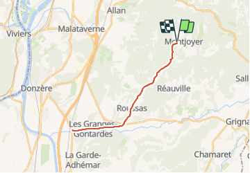

Length
25 km

Max alt
321 m

Uphill gradient
319 m
Km-Effort
30 km

Min alt
71 m

Downhill gradient
320 m
Boucle
Yes
Creation date :
2023-11-19 13:11:04.935
Updated on :
2023-11-19 14:41:32.023
1h30
Difficulty : Medium

FREE GPS app for hiking
 SityTrail
IGN / Geographical institutes
SityTrail Plus
The world is yours!
About
Trail Road bike of 25 km to be discovered at Auvergne-Rhône-Alpes, Drôme, Montjoyer. This trail is proposed by micheleuvrard.
Positioning
Country:
France
Region :
Auvergne-Rhône-Alpes
Department/Province :
Drôme
Municipality :
Montjoyer
Location:
Unknown
Start:(Dec)
Start:(UTM)
646868 ; 4926510 (31T) N.
Comments