


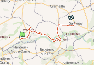
Saponay du 19/11/2023

VANDERPUTTENMi
User GUIDE

Length
11.2 km

Max alt
127 m

Uphill gradient
110 m
Km-Effort
12.7 km

Min alt
92 m

Downhill gradient
95 m
Boucle
No
Creation date :
2023-11-19 07:39:02.264
Updated on :
2023-11-19 16:34:08.481
2h52
Difficulty : Difficult

FREE GPS app for hiking
 SityTrail
IGN / Geographical institutes
SityTrail Plus
The world is yours!
About
Trail Walking of 11.2 km to be discovered at Hauts-de-France, Aisne, Oulchy-le-Château. This trail is proposed by VANDERPUTTENMi.
Photos

Positioning
Country:
France
Region :
Hauts-de-France
Department/Province :
Aisne
Municipality :
Oulchy-le-Château
Location:
Unknown
Start:(Dec)
Start:(UTM)
529583 ; 5449775 (31U) N.
Comments