


marsaou Mandelieu

clintest
User
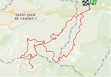

Length
17 km

Max alt
542 m

Uphill gradient
665 m
Km-Effort
26 km

Min alt
50 m

Downhill gradient
666 m
Boucle
Yes
Creation date :
2023-11-19 07:29:47.254
Updated on :
2023-11-19 15:25:53.878
7h54
Difficulty : Very difficult

FREE GPS app for hiking
 SityTrail
IGN / Geographical institutes
SityTrail Plus
The world is yours!
About
Trail Walking of 17 km to be discovered at Provence-Alpes-Côte d'Azur, Maritime Alps, Mandelieu-la-Napoule. This trail is proposed by clintest.
Positioning
Country:
France
Region :
Provence-Alpes-Côte d'Azur
Department/Province :
Maritime Alps
Municipality :
Mandelieu-la-Napoule
Location:
Unknown
Start:(Dec)
Start:(UTM)
330473 ; 4821224 (32T) N.
Comments