


Foret Momonrecy 10km

pmauvieux
User
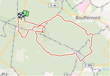

Length
10.8 km

Max alt
203 m

Uphill gradient
196 m
Km-Effort
13.4 km

Min alt
99 m

Downhill gradient
189 m
Boucle
Yes
Creation date :
2023-11-19 08:46:43.739
Updated on :
2023-11-19 15:41:01.238
2h03
Difficulty : Difficult

FREE GPS app for hiking
 SityTrail
IGN / Geographical institutes
SityTrail Plus
The world is yours!
About
Trail Walking of 10.8 km to be discovered at Ile-de-France, Val-d'Oise, Chauvry. This trail is proposed by pmauvieux.
Positioning
Country:
France
Region :
Ile-de-France
Department/Province :
Val-d'Oise
Municipality :
Chauvry
Location:
Unknown
Start:(Dec)
Start:(UTM)
446056 ; 5432397 (31U) N.
Comments