


Manières 20 nov. 23

pje
User
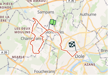

Length
14.1 km

Max alt
296 m

Uphill gradient
197 m
Km-Effort
16.8 km

Min alt
209 m

Downhill gradient
226 m
Boucle
No
Creation date :
2023-11-20 07:57:29.442
Updated on :
2023-11-20 10:40:52.456
2h43
Difficulty : Very easy

FREE GPS app for hiking
 SityTrail
IGN / Geographical institutes
SityTrail Plus
The world is yours!
About
Trail Walking of 14.1 km to be discovered at Bourgogne-Franche-Comté, Jura, Monnières. This trail is proposed by pje.
Positioning
Country:
France
Region :
Bourgogne-Franche-Comté
Department/Province :
Jura
Municipality :
Monnières
Location:
Unknown
Start:(Dec)
Start:(UTM)
686427 ; 5220691 (31T) N.
Comments