


St Pierre 201123

JMCMoreau
User
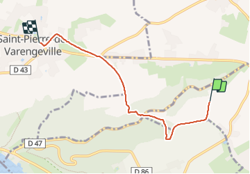

Length
4.8 km

Max alt
131 m

Uphill gradient
82 m
Km-Effort
5.9 km

Min alt
62 m

Downhill gradient
80 m
Boucle
No
Creation date :
2023-11-20 09:23:53.563
Updated on :
2023-11-20 10:41:25.122
1h17
Difficulty : Easy

FREE GPS app for hiking
 SityTrail
IGN / Geographical institutes
SityTrail Plus
The world is yours!
About
Trail Walking of 4.8 km to be discovered at Normandy, Seine-Maritime, La Vaupalière. This trail is proposed by JMCMoreau.
Positioning
Country:
France
Region :
Normandy
Department/Province :
Seine-Maritime
Municipality :
La Vaupalière
Location:
Unknown
Start:(Dec)
Start:(UTM)
353163 ; 5484235 (31U) N.
Comments