


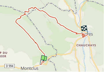
Tour du Rocher de Jardanne (Serres 05)

Clo0413
User

Length
8.7 km

Max alt
1354 m

Uphill gradient
655 m
Km-Effort
17.6 km

Min alt
660 m

Downhill gradient
705 m
Boucle
No
Creation date :
2023-11-20 08:36:06.214
Updated on :
2023-12-10 18:09:36.838
3h59
Difficulty : Difficult

FREE GPS app for hiking
 SityTrail
IGN / Geographical institutes
SityTrail Plus
The world is yours!
About
Trail Walking of 8.7 km to be discovered at Provence-Alpes-Côte d'Azur, Hautes-Alpes, Montclus. This trail is proposed by Clo0413.
Positioning
Country:
France
Region :
Provence-Alpes-Côte d'Azur
Department/Province :
Hautes-Alpes
Municipality :
Montclus
Location:
Unknown
Start:(Dec)
Start:(UTM)
714075 ; 4921663 (31T) N.
Comments