Rognes 21 novembre 2023

rlebasque
User
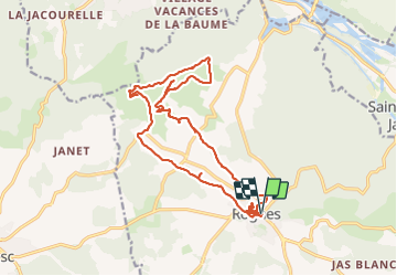

Length
20 km

Max alt
432 m

Uphill gradient
519 m
Km-Effort
27 km

Min alt
223 m

Downhill gradient
519 m
Boucle
Yes
Creation date :
2023-11-21 08:09:48.906
Updated on :
2023-11-21 15:01:44.983
6h50
Difficulty : Very difficult

FREE GPS app for hiking
 SityTrail
IGN / Geographical institutes
SityTrail Plus
The world is yours!
About
Trail Walking of 20 km to be discovered at Provence-Alpes-Côte d'Azur, Bouches-du-Rhône, Rognes. This trail is proposed by rlebasque.
Positioning
Country:
France
Region :
Provence-Alpes-Côte d'Azur
Department/Province :
Bouches-du-Rhône
Municipality :
Rognes
Location:
Unknown
Start:(Dec)
Start:(UTM)
689376 ; 4837228 (31T) N.
Comments