


2023-11-21_18h24m04_L 01

LUTZMarc
User
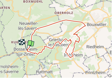

Length
17.6 km

Max alt
322 m

Uphill gradient
295 m
Km-Effort
22 km

Min alt
181 m

Downhill gradient
298 m
Boucle
Yes
Creation date :
2023-11-21 17:24:04.845
Updated on :
2024-11-01 09:11:40.744
4h54
Difficulty : Medium

FREE GPS app for hiking
 SityTrail
IGN / Geographical institutes
SityTrail Plus
The world is yours!
About
Trail Walking of 17.6 km to be discovered at Grand Est, Bas-Rhin, Dossenheim-sur-Zinsel. This trail is proposed by LUTZMarc.
Description
Facile
Resto Bastberger stuebel à Imsheim
Positioning
Country:
France
Region :
Grand Est
Department/Province :
Bas-Rhin
Municipality :
Dossenheim-sur-Zinsel
Location:
Unknown
Start:(Dec)
Start:(UTM)
382706 ; 5407216 (32U) N.
Comments