2023-11-21_19h18m15_SityTrail - 3859304 - claviers-la-pigne-x83x-1

clintest
User
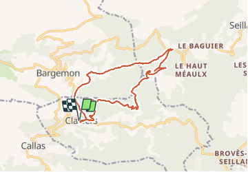

Length
16.2 km

Max alt
754 m

Uphill gradient
541 m
Km-Effort
23 km

Min alt
344 m

Downhill gradient
541 m
Boucle
Yes
Creation date :
2023-11-21 18:18:17.034
Updated on :
2023-11-21 18:18:19.376

FREE GPS app for hiking
 SityTrail
IGN / Geographical institutes
SityTrail Plus
The world is yours!
About
Trail of 16.2 km to be discovered at Provence-Alpes-Côte d'Azur, Var, Claviers. This trail is proposed by clintest.
Positioning
Country:
France
Region :
Provence-Alpes-Côte d'Azur
Department/Province :
Var
Municipality :
Claviers
Location:
Unknown
Start:(Dec)
Start:(UTM)
303236 ; 4830532 (32T) N.
Comments