


blavet

clintest
User
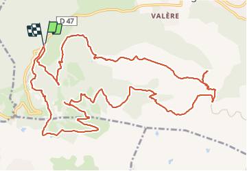

Length
17.4 km

Max alt
419 m

Uphill gradient
557 m
Km-Effort
25 km

Min alt
91 m

Downhill gradient
558 m
Boucle
Yes
Creation date :
2023-11-22 08:05:21.41
Updated on :
2023-11-22 14:33:39.53
6h24
Difficulty : Very difficult

FREE GPS app for hiking
 SityTrail
IGN / Geographical institutes
SityTrail Plus
The world is yours!
About
Trail Walking of 17.4 km to be discovered at Provence-Alpes-Côte d'Azur, Var, Bagnols-en-Forêt. This trail is proposed by clintest.
Positioning
Country:
France
Region :
Provence-Alpes-Côte d'Azur
Department/Province :
Var
Municipality :
Bagnols-en-Forêt
Location:
Unknown
Start:(Dec)
Start:(UTM)
310501 ; 4822220 (32T) N.
Comments