


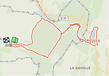
Rivoire Meyriat Marron

HB01
User

Length
14.4 km

Max alt
934 m

Uphill gradient
428 m
Km-Effort
20 km

Min alt
771 m

Downhill gradient
428 m
Boucle
Yes
Creation date :
2023-11-23 08:42:33.306
Updated on :
2023-11-24 09:36:29.252
3h59
Difficulty : Medium

FREE GPS app for hiking
 SityTrail
IGN / Geographical institutes
SityTrail Plus
The world is yours!
About
Trail Walking of 14.4 km to be discovered at Auvergne-Rhône-Alpes, Ain, Vieu-d'Izenave. This trail is proposed by HB01.
Description
Départ Rivoire
Positioning
Country:
France
Region :
Auvergne-Rhône-Alpes
Department/Province :
Ain
Municipality :
Vieu-d'Izenave
Location:
Unknown
Start:(Dec)
Start:(UTM)
698056 ; 5106449 (31T) N.
Comments