


Coincy du 23-11-2023

VANDERPUTTENMi
User GUIDE

Length
10.7 km

Max alt
140 m

Uphill gradient
135 m
Km-Effort
12.5 km

Min alt
95 m

Downhill gradient
138 m
Boucle
Yes
Creation date :
2023-11-23 12:53:03.408
Updated on :
2023-11-29 20:37:32.185
2h50
Difficulty : Difficult

FREE GPS app for hiking
 SityTrail
IGN / Geographical institutes
SityTrail Plus
The world is yours!
About
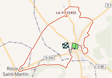
Trail Walking of 10.7 km to be discovered at Hauts-de-France, Aisne, Coincy. This trail is proposed by VANDERPUTTENMi.
Photos

Positioning
Country:
France
Region :
Hauts-de-France
Department/Province :
Aisne
Municipality :
Coincy
Location:
Unknown
Start:(Dec)
Start:(UTM)
530488 ; 5445220 (31U) N.
Comments