


De Rognac vers le Collet Redon

Nathy8913
User
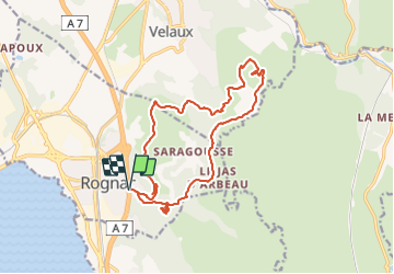

Length
17 km

Max alt
223 m

Uphill gradient
438 m
Km-Effort
23 km

Min alt
56 m

Downhill gradient
439 m
Boucle
Yes
Creation date :
2023-11-24 13:27:06.509
Updated on :
2023-11-24 13:27:33.288

FREE GPS app for hiking
 SityTrail
IGN / Geographical institutes
SityTrail Plus
The world is yours!
About
Trail of 17 km to be discovered at Provence-Alpes-Côte d'Azur, Bouches-du-Rhône, Rognac. This trail is proposed by Nathy8913.
Points of interest


Positioning
Country:
France
Region :
Provence-Alpes-Côte d'Azur
Department/Province :
Bouches-du-Rhône
Municipality :
Rognac
Location:
Unknown
Start:(Dec)
Start:(UTM)
681238 ; 4817174 (31T) N.
Comments