


Cléry, Mézière, Marceau,Clery

Rembliere
User
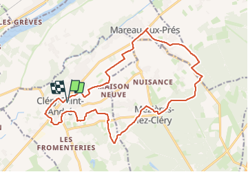

Length
20 km

Max alt
109 m

Uphill gradient
117 m
Km-Effort
22 km

Min alt
87 m

Downhill gradient
118 m
Boucle
Yes
Creation date :
2023-11-24 09:03:40.351
Updated on :
2023-11-24 16:07:49.43
4h31
Difficulty : Medium

FREE GPS app for hiking
 SityTrail
IGN / Geographical institutes
SityTrail Plus
The world is yours!
About
Trail Walking of 20 km to be discovered at Centre-Loire Valley, Loiret, Cléry-Saint-André. This trail is proposed by Rembliere.
Positioning
Country:
France
Region :
Centre-Loire Valley
Department/Province :
Loiret
Municipality :
Cléry-Saint-André
Location:
Unknown
Start:(Dec)
Start:(UTM)
407268 ; 5297325 (31T) N.
Comments