


20231125 ww*wwxx

Jeanclaudebic
User
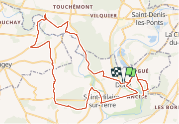

Length
26 km

Max alt
156 m

Uphill gradient
239 m
Km-Effort
29 km

Min alt
99 m

Downhill gradient
241 m
Boucle
Yes
Creation date :
2023-11-25 07:43:11.285
Updated on :
2023-11-25 15:19:03.564
6h10
Difficulty : Very difficult

FREE GPS app for hiking
 SityTrail
IGN / Geographical institutes
SityTrail Plus
The world is yours!
About
Trail Walking of 26 km to be discovered at Centre-Loire Valley, Eure-et-Loir, Cloyes-les-Trois-Rivières. This trail is proposed by Jeanclaudebic.
Positioning
Country:
France
Region :
Centre-Loire Valley
Department/Province :
Eure-et-Loir
Municipality :
Cloyes-les-Trois-Rivières
Location:
Unknown
Start:(Dec)
Start:(UTM)
371103 ; 5321809 (31U) N.
Comments