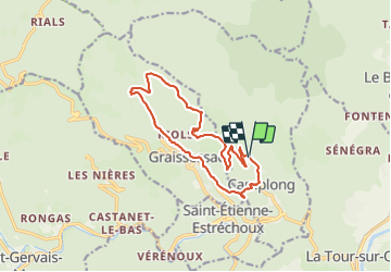
Le bassin minier Camplong-Graissessac en rive gauche

ARVIEU
User

Length
14 km

Max alt
693 m

Uphill gradient
576 m
Km-Effort
22 km

Min alt
308 m

Downhill gradient
573 m
Boucle
Yes
Creation date :
2023-11-25 19:38:15.233
Updated on :
2023-11-25 19:43:09.542
5h00
Difficulty : Medium

FREE GPS app for hiking
 SityTrail
IGN / Geographical institutes
SityTrail Plus
The world is yours!
About
Trail Walking of 14 km to be discovered at Occitania, Hérault, Camplong. This trail is proposed by ARVIEU.
Points of interest


Positioning
Country:
France
Region :
Occitania
Department/Province :
Hérault
Municipality :
Camplong
Location:
Unknown
Start:(Dec)
Start:(UTM)
509271 ; 4836162 (31T) N.
Comments