


Innimond Rossillon via le Molard de Don

malc
User
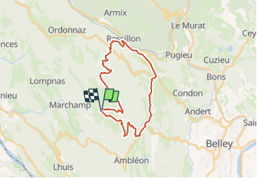

Length
28 km

Max alt
1214 m

Uphill gradient
1121 m
Km-Effort
43 km

Min alt
327 m

Downhill gradient
1122 m
Boucle
Yes
Creation date :
2023-11-26 09:22:40.98
Updated on :
2023-11-26 11:29:08.81
2h05
Difficulty : Difficult

FREE GPS app for hiking
 SityTrail
IGN / Geographical institutes
SityTrail Plus
The world is yours!
About
Trail Mountain bike of 28 km to be discovered at Auvergne-Rhône-Alpes, Ain, Innimond. This trail is proposed by malc.
Description
descente bien engagé , fait en VTTAE
Positioning
Country:
France
Region :
Auvergne-Rhône-Alpes
Department/Province :
Ain
Municipality :
Innimond
Location:
Unknown
Start:(Dec)
Start:(UTM)
700008 ; 5073078 (31T) N.
Comments