


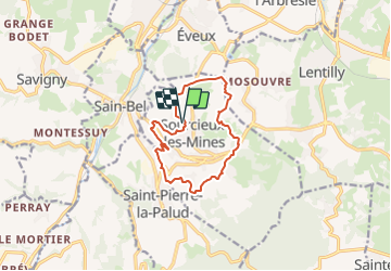
2023-11-27_00h47m21_fiche-verte-n17-sourcieux-les-mines_randonnee-22453089

daniellebou
User

Length
11.5 km

Max alt
501 m

Uphill gradient
356 m
Km-Effort
16.3 km

Min alt
287 m

Downhill gradient
354 m
Boucle
Yes
Creation date :
2023-11-26 23:47:21.27
Updated on :
2023-12-28 19:22:06.157
3h41
Difficulty : Difficult

FREE GPS app for hiking
 SityTrail
IGN / Geographical institutes
SityTrail Plus
The world is yours!
About
Trail Walking of 11.5 km to be discovered at Auvergne-Rhône-Alpes, Rhône, Sourcieux-les-Mines. This trail is proposed by daniellebou.
Positioning
Country:
France
Region :
Auvergne-Rhône-Alpes
Department/Province :
Rhône
Municipality :
Sourcieux-les-Mines
Location:
Unknown
Start:(Dec)
Start:(UTM)
625823 ; 5073841 (31T) N.
Comments