


SityTrail - couronne de Charlemagne Cassis

Jack29
User
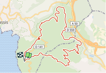

Length
14 km

Max alt
328 m

Uphill gradient
435 m
Km-Effort
19.8 km

Min alt
118 m

Downhill gradient
427 m
Boucle
Yes
Creation date :
2023-11-28 10:50:52.964
Updated on :
2023-11-28 11:06:01.526
4h29
Difficulty : Medium

FREE GPS app for hiking
 SityTrail
IGN / Geographical institutes
SityTrail Plus
The world is yours!
About
Trail Walking of 14 km to be discovered at Provence-Alpes-Côte d'Azur, Bouches-du-Rhône, Cassis. This trail is proposed by Jack29.
Positioning
Country:
France
Region :
Provence-Alpes-Côte d'Azur
Department/Province :
Bouches-du-Rhône
Municipality :
Cassis
Location:
Unknown
Start:(Dec)
Start:(UTM)
707421 ; 4785867 (31T) N.
Comments