


28 11 23

micheleuvrard
User
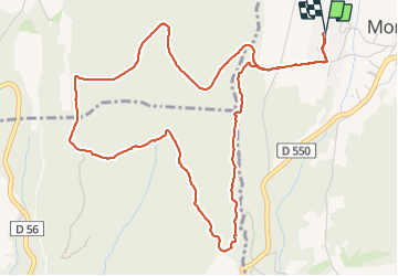

Length
6.5 km

Max alt
336 m

Uphill gradient
108 m
Km-Effort
8 km

Min alt
255 m

Downhill gradient
108 m
Boucle
Yes
Creation date :
2023-11-28 13:46:34.833
Updated on :
2023-11-28 15:25:02.983
1h38
Difficulty : Medium

FREE GPS app for hiking
 SityTrail
IGN / Geographical institutes
SityTrail Plus
The world is yours!
About
Trail Walking of 6.5 km to be discovered at Auvergne-Rhône-Alpes, Drôme, Montjoyer. This trail is proposed by micheleuvrard.
Positioning
Country:
France
Region :
Auvergne-Rhône-Alpes
Department/Province :
Drôme
Municipality :
Montjoyer
Location:
Unknown
Start:(Dec)
Start:(UTM)
646873 ; 4926506 (31T) N.
Comments