


La Dent de Moirans G1

MICDURAND
User
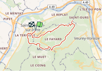

Length
15.9 km

Max alt
990 m

Uphill gradient
862 m
Km-Effort
27 km

Min alt
224 m

Downhill gradient
862 m
Boucle
Yes
Creation date :
2023-11-29 21:16:15.653
Updated on :
2023-11-29 21:16:38.321
6h13
Difficulty : Very difficult

FREE GPS app for hiking
 SityTrail
IGN / Geographical institutes
SityTrail Plus
The world is yours!
About
Trail Walking of 15.9 km to be discovered at Auvergne-Rhône-Alpes, Isère, Saint-Quentin-sur-Isère. This trail is proposed by MICDURAND.
Positioning
Country:
France
Region :
Auvergne-Rhône-Alpes
Department/Province :
Isère
Municipality :
Saint-Quentin-sur-Isère
Location:
Unknown
Start:(Dec)
Start:(UTM)
700072 ; 5017056 (31T) N.
Comments