


depart l'étang rouge vers champrougier

gerardmicheline
User
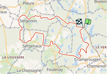

Length
23 km

Max alt
233 m

Uphill gradient
247 m
Km-Effort
26 km

Min alt
193 m

Downhill gradient
243 m
Boucle
Yes
Creation date :
2023-12-01 13:32:51.489
Updated on :
2023-12-01 13:35:32.968
5h53
Difficulty : Very difficult

FREE GPS app for hiking
 SityTrail
IGN / Geographical institutes
SityTrail Plus
The world is yours!
About
Trail Walking of 23 km to be discovered at Bourgogne-Franche-Comté, Jura, Champrougier. This trail is proposed by gerardmicheline.
Positioning
Country:
France
Region :
Bourgogne-Franche-Comté
Department/Province :
Jura
Municipality :
Champrougier
Location:
Unknown
Start:(Dec)
Start:(UTM)
691873 ; 5196783 (31T) N.
Comments