


eu se yo

bernir
User
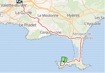

Length
26 km

Max alt
98 m

Uphill gradient
264 m
Km-Effort
29 km

Min alt
-2 m

Downhill gradient
288 m
Boucle
No
Creation date :
2023-12-02 13:59:45.693
Updated on :
2023-12-02 15:47:04.341
1h47
Difficulty : Easy

FREE GPS app for hiking
 SityTrail
IGN / Geographical institutes
SityTrail Plus
The world is yours!
About
Trail Walking of 26 km to be discovered at Provence-Alpes-Côte d'Azur, Var, Hyères. This trail is proposed by bernir.
Positioning
Country:
France
Region :
Provence-Alpes-Côte d'Azur
Department/Province :
Var
Municipality :
Hyères
Location:
Unknown
Start:(Dec)
Start:(UTM)
263698 ; 4768547 (32T) N.
Comments