


tromp, pied 🐏,tube

dimchamp
User
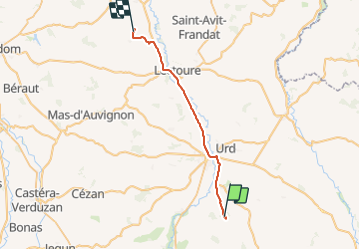

Length
32 km

Max alt
181 m

Uphill gradient
249 m
Km-Effort
36 km

Min alt
73 m

Downhill gradient
243 m
Boucle
No
Creation date :
2023-12-02 13:41:14.484
Updated on :
2023-12-02 19:23:07.045
5h41
Difficulty : Very difficult

FREE GPS app for hiking
 SityTrail
IGN / Geographical institutes
SityTrail Plus
The world is yours!
About
Trail Walking of 32 km to be discovered at Occitania, Gers, Miramont-Latour. This trail is proposed by dimchamp.
Positioning
Country:
France
Region :
Occitania
Department/Province :
Gers
Municipality :
Miramont-Latour
Location:
Unknown
Start:(Dec)
Start:(UTM)
313925 ; 4851148 (31T) N.
Comments