


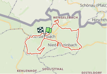
Ancien Circuit Obersteinbach Boucle

Tourisme Equestre Alsace
Promouvoir le Tourisme Equestre en Alsace GUIDE+

Length
19.8 km

Max alt
417 m

Uphill gradient
584 m
Km-Effort
28 km

Min alt
216 m

Downhill gradient
584 m
Boucle
Yes
Creation date :
2023-12-04 19:32:26.377
Updated on :
2023-12-04 19:33:32.231
3h37
Difficulty : Medium

FREE GPS app for hiking
 SityTrail
IGN / Geographical institutes
SityTrail Plus
The world is yours!
About
Trail Horseback riding of 19.8 km to be discovered at Grand Est, Bas-Rhin, Obersteinbach. This trail is proposed by Tourisme Equestre Alsace.
Photos

Positioning
Country:
France
Region :
Grand Est
Department/Province :
Bas-Rhin
Municipality :
Obersteinbach
Location:
Unknown
Start:(Dec)
Start:(UTM)
404353 ; 5432325 (32U) N.
Comments