


Ancien Circuit Lampertsloch Obersteinbach

Tourisme Equestre Alsace
Promouvoir le Tourisme Equestre en Alsace GUIDE+
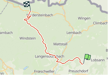

Length
21 km

Max alt
412 m

Uphill gradient
522 m
Km-Effort
28 km

Min alt
172 m

Downhill gradient
484 m
Boucle
No
Creation date :
2023-12-04 19:34:12.677
Updated on :
2023-12-04 19:34:45.45
3h40
Difficulty : Medium

FREE GPS app for hiking
 SityTrail
IGN / Geographical institutes
SityTrail Plus
The world is yours!
About
Trail Horseback riding of 21 km to be discovered at Grand Est, Bas-Rhin, Lampertsloch. This trail is proposed by Tourisme Equestre Alsace.
Photos


Positioning
Country:
France
Region :
Grand Est
Department/Province :
Bas-Rhin
Municipality :
Lampertsloch
Location:
Unknown
Start:(Dec)
Start:(UTM)
413033 ; 5423321 (32U) N.
Comments