


Rieutort de randon Truc de Fortunio

Alain28/01
User
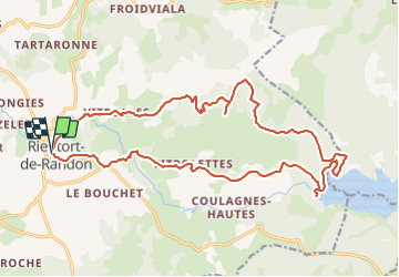

Length
23 km

Max alt
1540 m

Uphill gradient
637 m
Km-Effort
31 km

Min alt
1114 m

Downhill gradient
640 m
Boucle
Yes
Creation date :
2023-12-05 17:09:31.678
Updated on :
2023-12-05 17:11:03.732
7h09
Difficulty : Difficult

FREE GPS app for hiking
 SityTrail
IGN / Geographical institutes
SityTrail Plus
The world is yours!
About
Trail Walking of 23 km to be discovered at Occitania, Lozère, Monts-de-Randon. This trail is proposed by Alain28/01.
Positioning
Country:
France
Region :
Occitania
Department/Province :
Lozère
Municipality :
Monts-de-Randon
Location:
Unknown
Start:(Dec)
Start:(UTM)
537918 ; 4942439 (31T) N.
Comments