


Ste Victoire - Mont des Mouches - La Citadelle

GeorgesV.
User
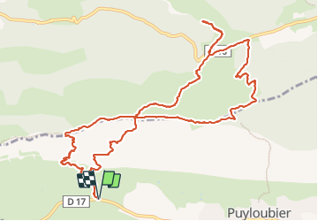

Length
14.4 km

Max alt
998 m

Uphill gradient
1008 m
Km-Effort
28 km

Min alt
402 m

Downhill gradient
1009 m
Boucle
Yes
Creation date :
2023-12-06 07:26:27.0
Updated on :
2023-12-06 21:19:37.959
6h18
Difficulty : Very difficult

FREE GPS app for hiking
 SityTrail
IGN / Geographical institutes
SityTrail Plus
The world is yours!
About
Trail Walking of 14.4 km to be discovered at Provence-Alpes-Côte d'Azur, Bouches-du-Rhône, Puyloubier. This trail is proposed by GeorgesV..
Description
Très difficile !
Positioning
Country:
France
Region :
Provence-Alpes-Côte d'Azur
Department/Province :
Bouches-du-Rhône
Municipality :
Puyloubier
Location:
Unknown
Start:(Dec)
Start:(UTM)
713620 ; 4822843 (31T) N.
Comments