


grane tte sud

ymobernard
User
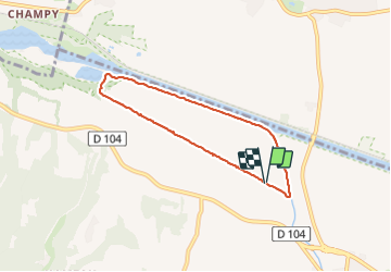

Length
6.4 km

Max alt
149 m

Uphill gradient
36 m
Km-Effort
6.9 km

Min alt
127 m

Downhill gradient
38 m
Boucle
Yes
Creation date :
2023-12-06 13:16:48.935
Updated on :
2023-12-06 15:29:09.969
1h44
Difficulty : Easy

FREE GPS app for hiking
 SityTrail
IGN / Geographical institutes
SityTrail Plus
The world is yours!
About
Trail Walking of 6.4 km to be discovered at Auvergne-Rhône-Alpes, Drôme, Grane. This trail is proposed by ymobernard.
Positioning
Country:
France
Region :
Auvergne-Rhône-Alpes
Department/Province :
Drôme
Municipality :
Grane
Location:
Unknown
Start:(Dec)
Start:(UTM)
651357 ; 4956183 (31T) N.
Comments