Trail Horseback riding Silz - Circuit Palatinat Silz Darstein - Photo

Promouvoir le Tourisme Equestre en Alsace GUIDE+

© OpenStreetMap contributors
Length
Length
8.4 km
Max alt
Max alt
367 m
Uphill gradient
Uphill gradient
266 m
Km-Effort
Km-Effort  
11.8 km
Min alt
Min alt
224 m
Downhill gradient
Downhill gradient
212 m
Boucle
Boucle
No
Creation date :
2023-12-06 17:11:32.303
Updated on :
2023-12-06 17:12:28.209

(0 Reviews)

Horseback riding
Horseback riding
1h33
Difficulty : Easy

Scan this QR Code to open this trail in the SityTrail application

FREE GPS app for hiking

Logo SityTrail SityTrail

IGN / Geographical institutes

Download SityTrail from the App Store Download SityTrail from Google Play

Logo SityTrail SityTrail World

The world is yours!

Download SityTrail from the App Store Download SityTrail from Google Play Download SityTrail on Huawei AppGallery

About

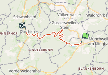
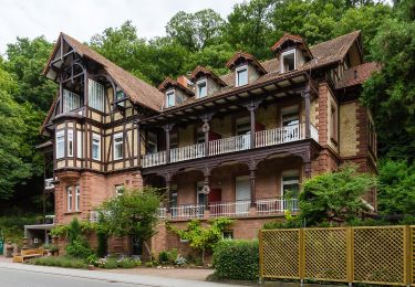
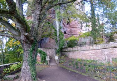
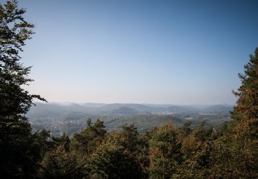
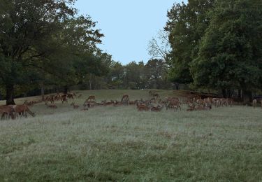
Trail Horseback riding of 8.4 km to be discovered at Rhineland-Palatinate, Landkreis Südliche Weinstraße, Silz. This trail is proposed by Tourisme Equestre Alsace.

Elevation profile

Photos

Positioning

Country:
Germany
Region :
Rhineland-Palatinate
Department/Province :
Landkreis Südliche Weinstraße
Municipality :
Silz
Location:
Unknown
Start:(UTM)
423149 ; 5444472 (32U) N.

Trails nearby

Trail On foot Leinsweiler - PWV 15 - Photo
On foot
PRO

On foot

Easy
Leinsweiler, Rhineland-Palatinate, Landkreis Südliche Weinstraße, Germany
6.5 km | 9.9 km-effort
2h 14min
Yes
Trail On foot Bad Bergzabern - Rund um den Steinkopf, Blankenborn - Photo
On foot
PRO

On foot

Easy
Bad Bergzabern, Rhineland-Palatinate, Landkreis Südliche Weinstraße, Germany
6 km | 8.1 km-effort
1h 51min
Yes
Trail On foot Gleiszellen-Gleishorbach - Karlsplatzweg, Klingenmüster - Photo
On foot
PRO

On foot

Easy
Gleiszellen-Gleishorbach, Rhineland-Palatinate, Landkreis Südliche Weinstraße, Germany
6.3 km | 9.5 km-effort
2h 9min
Yes
Trail On foot Gleiszellen-Gleishorbach - Gleiszellen: Sauhausbrunnen-Weg - Photo
On foot
PRO

On foot

Easy
Gleiszellen-Gleishorbach, Rhineland-Palatinate, Landkreis Südliche Weinstraße, Germany
11.1 km | 15.4 km-effort
3h 30min
Yes
Trail On foot Gleiszellen-Gleishorbach - Gleiszellen: Mischwald-Wanderweg - Photo
On foot
PRO

On foot

Easy
Gleiszellen-Gleishorbach, Rhineland-Palatinate, Landkreis Südliche Weinstraße, Germany
10 km | 14.1 km-effort
3h 11min
Yes
Trail On foot Bad Bergzabern - Bad Bergzabern: Tabernae-Montanus-Weg - Photo
On foot
PRO

On foot

Easy
Bad Bergzabern, Rhineland-Palatinate, Landkreis Südliche Weinstraße, Germany
10.7 km | 15.9 km-effort
3h 36min
Yes
Trail On foot Erlenbach bei Dahn - Hans-Trapp-Tour - Photo
On foot
PRO

On foot

Easy
Erlenbach bei Dahn, Rhineland-Palatinate, Südwestpfalz, Germany
12.3 km | 17.5 km-effort
3h 59min
Yes
Trail On foot Münchweiler am Klingbach - Quellenweg Klingenmünster - Photo
On foot
PRO

On foot

Easy
Münchweiler am Klingbach, Rhineland-Palatinate, Landkreis Südliche Weinstraße, Germany
5.5 km | 8 km-effort
1h 49min
Yes
Trail On foot Silz - Schneckenpfad: Silz <=> Bethof - Photo
On foot
PRO

On foot

Easy
Silz, Rhineland-Palatinate, Landkreis Südliche Weinstraße, Germany
3.3 km | 4.3 km-effort
58min
No


Close
My subscriptions