


Carantec Henvic

taguette
User
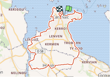

Length
24 km

Max alt
78 m

Uphill gradient
419 m
Km-Effort
30 km

Min alt
0 m

Downhill gradient
417 m
Boucle
Yes
Creation date :
2023-12-06 09:05:32.169
Updated on :
2023-12-06 18:38:20.771
6h15
Difficulty : Difficult

FREE GPS app for hiking
 SityTrail
IGN / Geographical institutes
SityTrail Plus
The world is yours!
About
Trail Walking of 24 km to be discovered at Brittany, Finistère, Carantec. This trail is proposed by taguette.
Positioning
Country:
France
Region :
Brittany
Department/Province :
Finistère
Municipality :
Carantec
Location:
Unknown
Start:(Dec)
Start:(UTM)
433026 ; 5391114 (30U) N.
Comments