


Locquénolé

taguette
User
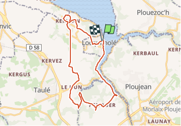

Length
16.3 km

Max alt
90 m

Uphill gradient
300 m
Km-Effort
20 km

Min alt
2 m

Downhill gradient
295 m
Boucle
Yes
Creation date :
2023-12-07 08:23:20.915
Updated on :
2023-12-07 12:05:30.67
3h12
Difficulty : Medium

FREE GPS app for hiking
 SityTrail
IGN / Geographical institutes
SityTrail Plus
The world is yours!
About
Trail Walking of 16.3 km to be discovered at Brittany, Finistère, Locquénolé. This trail is proposed by taguette.
Positioning
Country:
France
Region :
Brittany
Department/Province :
Finistère
Municipality :
Locquénolé
Location:
Unknown
Start:(Dec)
Start:(UTM)
436805 ; 5386254 (30U) N.
Comments