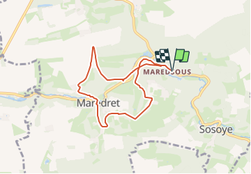
Trail On foot Anhée - Maredsous 6,6 km - Photo

Maredsous 6,6 km

 dejongm
dejongm

User

© OpenStreetMap contributors
Length
Length
6.6 km
Max alt
Max alt
258 m
Uphill gradient
Uphill gradient
172 m
Km-Effort
Km-Effort  
8.9 km
Min alt
Min alt
175 m
Downhill gradient
Downhill gradient
172 m
Boucle
Boucle
Yes
Creation date :
2023-12-08 08:42:56.834
Updated on :
2023-12-08 08:44:50.544

(0 Reviews)

On foot
On foot
2h00
Difficulty : Easy

Scan this QR Code to open this trail in the SityTrail application

FREE GPS app for hiking

Logo SityTrail SityTrail

IGN / Geographical institutes

Download SityTrail from the App Store Download SityTrail from Google Play

Logo SityTrail SityTrail Plus

The world is yours!

Download SityTrail from the App Store Download SityTrail from Google Play Download SityTrail on Huawei AppGallery

About

Trail On foot of 6.6 km to be discovered at Wallonia, Namur, Anhée. This trail is proposed by dejongm.

Elevation profile

Points of interest

Point of interest Anhée - Gare de Maredret - Photo
dejongm
Point of interest Anhée - Maredsous - Photo
dejongm
ANHÉE 
Point of interest Anhée - Rue des Laidmonts - Photo
dejongm
Point of interest Anhée - Rue Neuve Niole - Photo
dejongm
Point of interest Anhée - Maredret - Photo
dejongm
ANHÉE 
Point of interest Anhée - Abbaye de Maredsous - Photo
dejongm
Point of interest Anhée - Abdij van Maredret - Photo
dejongm

Positioning

Country:
Belgium
Region :
Wallonia
Department/Province :
Namur
Municipality :
Anhée
Location:
Unknown
Start:(Dec)
Start:(UTM)
626103 ; 5574010 (31U) N.


Close
My subscriptions