


cherb

AMOURETTE
User

Length
10.4 km

Max alt
24 m

Uphill gradient
101 m
Km-Effort
11.7 km

Min alt
-2 m

Downhill gradient
101 m
Boucle
Yes
Creation date :
2023-12-08 13:00:02.158
Updated on :
2023-12-08 15:30:04.0
2h08
Difficulty : Medium

FREE GPS app for hiking
 SityTrail
IGN / Geographical institutes
SityTrail Plus
The world is yours!
About
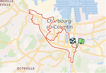
Trail Walking of 10.4 km to be discovered at Normandy, Manche, Cherbourg-en-Cotentin. This trail is proposed by AMOURETTE.
Positioning
Country:
France
Region :
Normandy
Department/Province :
Manche
Municipality :
Cherbourg-en-Cotentin
Location:
Cherbourg-Octeville
Start:(Dec)
Start:(UTM)
600034 ; 5498795 (30U) N.
Comments