


serre de pans

chasle
User
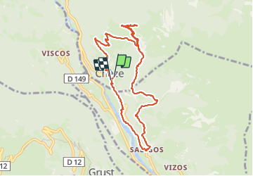

Length
10.4 km

Max alt
1379 m

Uphill gradient
772 m
Km-Effort
21 km

Min alt
634 m

Downhill gradient
796 m
Boucle
Yes
Creation date :
2023-12-10 07:57:41.135
Updated on :
2023-12-10 17:48:11.217
3h34
Difficulty : Medium

FREE GPS app for hiking
 SityTrail
IGN / Geographical institutes
SityTrail Plus
The world is yours!
About
Trail Walking of 10.4 km to be discovered at Occitania, Hautespyrenees, Chèze. This trail is proposed by chasle.
Positioning
Country:
France
Region :
Occitania
Department/Province :
Hautespyrenees
Municipality :
Chèze
Location:
Unknown
Start:(Dec)
Start:(UTM)
742567 ; 4754678 (30T) N.
Comments