Paris Sommets 2024

les randos d'Olivier
partout a pied et en moto

Length
16.7 km

Max alt
129 m

Uphill gradient
257 m
Km-Effort
20 km

Min alt
34 m

Downhill gradient
293 m
Boucle
No
Creation date :
2023-12-11 08:22:35.82
Updated on :
2023-12-11 08:27:32.653
4h35
Difficulty : Very difficult

FREE GPS app for hiking
 SityTrail
IGN / Geographical institutes
SityTrail Plus
The world is yours!
About
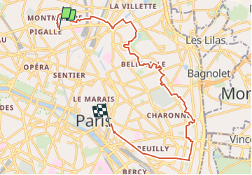
Trail Walking of 16.7 km to be discovered at Ile-de-France, Paris, Paris. This trail is proposed by les randos d'Olivier.
Positioning
Country:
France
Region :
Ile-de-France
Department/Province :
Paris
Municipality :
Paris
Location:
18th Arrondissement
Start:(Dec)
Start:(UTM)
451899 ; 5414651 (31U) N.
Comments